Report 1 - Canna Harbour
| Submitted: |
Peter Dann |
| |
Blue Moon (Parker 325) |
| |
Mar 2025 |
Canna is a very popular destination for those cruising the West Coast of Scotland: it has the most secure harbour in the Small Isles, is a convenient stop-over en route to the Outer Hebrides, and it has plenty of its own attractions to merit a visit: it’s a delightful island owned by the National Trust for Scotland with good walking, interesting sites to visit and an excellent seafood café/restaurant.
However, this combination makes it extremely popular in high season, and although the harbour has a dozen or so visitors’ buoys these are often all taken, so arriving much after teatime means anchoring in more exposed spots towards the entrance (quite lumpy especially in E/NE winds).
Unless, of course, you are in a Parker or Seal or some other, unmentionable, lift-keel yacht. Past the moorings the harbour dries out and turns to port behind the smaller island of Sanday which forms the southern side of the harbour. With suitable rise of tide and an eye on the echo sounder you can pick your anchoring spot by finding the whitest bit of sand in crystal clear water, drop the hook, raise the keel and wait for the tide to ebb. You will have this entire ‘inner harbour’ to yourself, and can walk ashore over hard sand either to Sanday or to Canna itself.
Exact anchoring spot will depend on the state of the tide (you may need to raise the keel a bit on the way in if you are well off HW, and you may not dry out at all at neaps) but I explored the whole area at springs and found no rocks, only kelp. The flattest area is slightly more to the Canna shore, and give the initial port hand turn headland on Sanday a good berth as there are some rocks off it, clearly marked on Antares charts. There shouldn’t be any need to go much further than level with the phone box on the Canna shore: here you will be protected from every direction, and can walk to the café and community shop in five minutes, carrying the dinghy if you plan on staying…
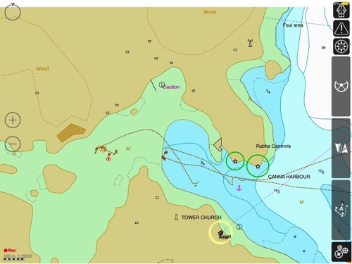
X marks the spot where I dried out very comfortably, slightly to the NW of the original waypoint to avoid some kelp. I measured this as drying 1.1m but take no responsibility for my maths.